
Published : 2025-11-25
Even if you have not experienced one personally, you certainly have some knowledge of the natural disaster of earthquakes, but do you know what a reservoir-induced earthquake is?
And what is the connection between reservoir-induced earthquakes and the Guangdong-Hong Kong region?
Reservoir-induced earthquakes are "man-made earthquakes"

The vast majority of earthquakes that occur on Earth are caused by natural forces, but some are related to human activities and to some extent "man-made". For example, building a reservoir can potentially trigger an earthquake, and the resulting earthquake is known as a reservoir-induced earthquake.
After a reservoir is built and filled with water, the immense pressure of the water body may trigger an earthquake. At the same time, as the pressure increases, more water is forced underground, which may widen existing subterranean fissures or even create new ones, leading to crustal instability.
Of course, a reservoir does not necessarily trigger an earthquake. It must be built on an active seismic fault, the dam must be high enough, meaning the water is deep enough, and the reservoir's capacity must be large enough.
According to incomplete statistics cited by the media, there are approximately 30,000 reservoirs worldwide with dams higher than 15 metres, and the proportion that have induced earthquakes is less than 0.3%.
In China, more than 80,000 reservoirs have been built, but only just over 30 have triggered earthquakes.
In addition, the intensity of earthquakes triggered by reservoirs is generally low. Worldwide, there have only been a total of four reservoir-induced earthquakes with a magnitude of 6 or above, with the strongest being magnitude 6.5.
Xinfengjiang reservoir triggers 6.1 magnitude earthquake

Humanity's ability to build large reservoirs is a recent development, so the history of reservoir-induced earthquakes is also very short. The world's first reservoir-induced earthquake was in 1931, at the Marathon Reservoir in Greece.
So, when and where did China's first reservoir-induced earthquake occur?
According to media reports, China's first reservoir-induced earthquake occurred on 19 March 1962, in the Xinfengjiang Reservoir area within Heyuan City, Guangdong, with a magnitude of 6.1, which is one of only four reservoir-induced earthquakes worldwide to exceed magnitude 6.
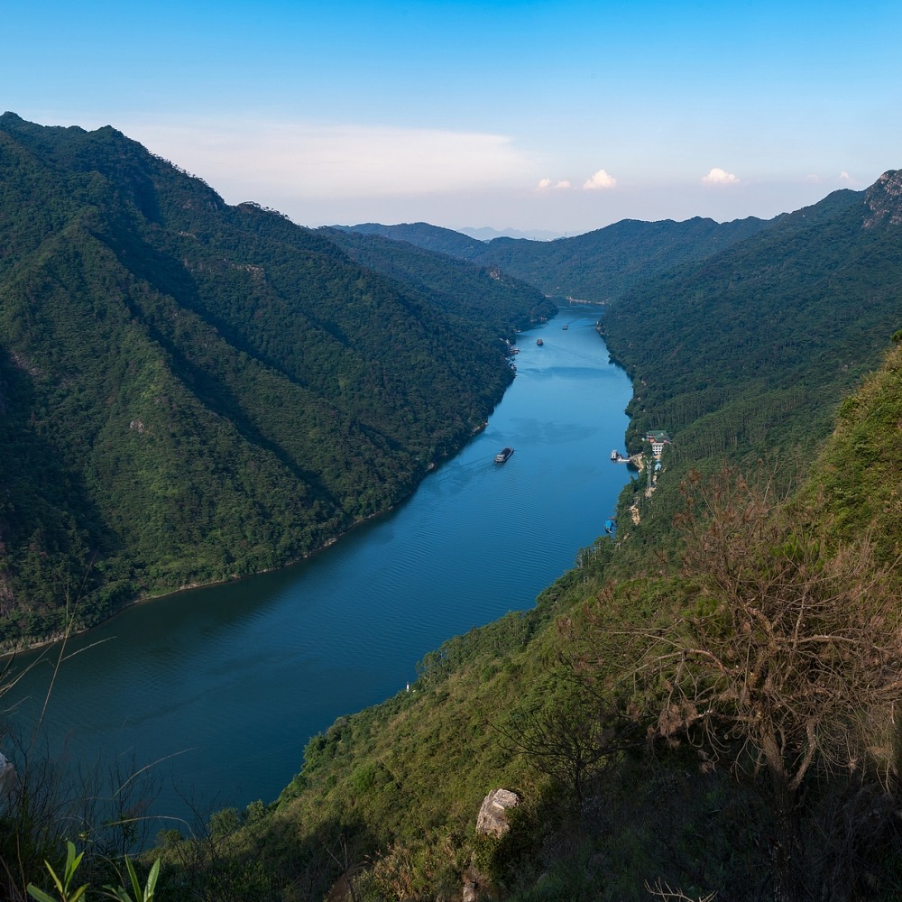
The Xinfengjiang is the largest tributary of the Dongjiang River, and the Xinfengjiang Reservoir is the largest artificial lake in South China, with an area of 370 square kilometres, equivalent to one-third of Hong Kong's land area.
Its maximum water depth exceeds 90 metres, roughly the height of a 30-storey building, and its total storage capacity is 13.9 billion cubic metres, enough to fill more than 550,000 standard swimming pools.
Construction of the Xinfengjiang Reservoir began in the 1950s. It is a large-scale water conservancy project primarily for power generation and flood control, with additional functions such as irrigation, water supply, and aquaculture.
Construction began in July 1958, and water impoundment started in October 1959. When the 6.1 magnitude earthquake occurred in March 1962, it was still in the water impoundment phase.
1,100 earthquakes occurred in Guangdong annually

It is worth noting here that although many media outlets have called the magnitude 6.1 earthquake the first reservoir-induced earthquake in Xinfengjiang and even in China, professional articles have mentioned that perceptible earthquakes had already occurred in the reservoir area one month after Xinfengjiang Reservoir began filling, when the water level reached 56 meters.
According to this, the date of China's first reservoir-induced earthquake would be earlier.
Have there been many earthquakes related to the Xinfengjiang Reservoir since then? Guangdong experiences an average of around 1,100 earthquakes per year, with more than half occurring in Heyuan.
As for how many of Heyuan's earthquakes are related to the reservoir, experts have not given a definitive answer, but they do mention that "Heyuan is located on fault zones such as the Heyuan-Shaowu fault and the Shijiao-Xingang-Baitian fault, and coupled with the seepage effect of the Xinfengjiang Reservoir, it possesses the structural conditions for earthquakes to occur, hence the relatively high number of local earthquakes....."
What is the connection between the earthquakes at Xinfengjiang Reservoir and Hong Kong? It is important to know that Heyuan, where the Xinfengjiang Reservoir is located, is just over a hundred kilometres from Hong Kong and is the main source of felt earthquakes in Hong Kong.
During the magnitude 6.1 reservoir-induced earthquake in 1962, buildings in Hong Kong swayed, and many residents were woken from their sleep and hastily went to the streets to take temporary shelter.
On 22 February 2013, more than 5,000 residents in Hong Kong reported the earthquake to the Observatory, and the epicentre of that magnitude 4.8 earthquake was also near the Xinfengjiang Reservoir in Heyuan.
Having discussed earthquakes, here's are some more information. It was mentioned earlier that the Xinfengjiang Reservoir was primarily used for power generation and flood control.
In fact, before the 1980s, the Xinfengjiang Hydropower Station accounted for more than half of the total electricity generation in Guangdong province.
However, after the 1990s, with social development, the reservoir's main purpose shifted to water supply, and it became an important source of the Dongjiang water supplied to Hong Kong.
Experts: earthquakes in the Three Gorges Dam reservoir area are minor

Finally, when it comes to reservoir-induced earthquakes, many people may wonder whether the Three Gorges Dam reservoir, a project of the century, can also trigger earthquakes? The answer is yes, but there's no need to worry.
Academician Shen Guofang, head of the phased assessment project team for the experimental impoundment of the Three Gorges Dam project and former vice president of the Chinese Academy of Engineering, stated clearly in an interview with official media:
"Monitoring data shows that during the impoundment period, seismic activity in the Three Gorges Dam reservoir area is dominated by micro-earthquakes and extremely micro-earthquakes, mainly caused by the inundation of karst and mine caves.
The largest earthquake recorded in the Three Gorges Dam reservoir area was a magnitude 4.1 in November 2008 during the initial impoundment period, which is far smaller than the predicted value of 'can be considered as 5.5 magnitude' proposed in the preliminary design and feasibility study report."
According to reports, earthquakes induced by a dam generally occur in the initial period after its completion. Over time, the geological structure beneath the dam tends to stabilise, and the probability of the dam inducing an earthquake will further decrease.
Shen Guofang emphasised that neither the 2008 Wenchuan earthquake nor the 2013 Lushan earthquake in Sichuan were directly related to the Three Gorges Dam reservoir.
Read more: China experiences 30+ earthquakes of magnitude 5+ annually
Read more: China built the world's strongest earthquake early warning project